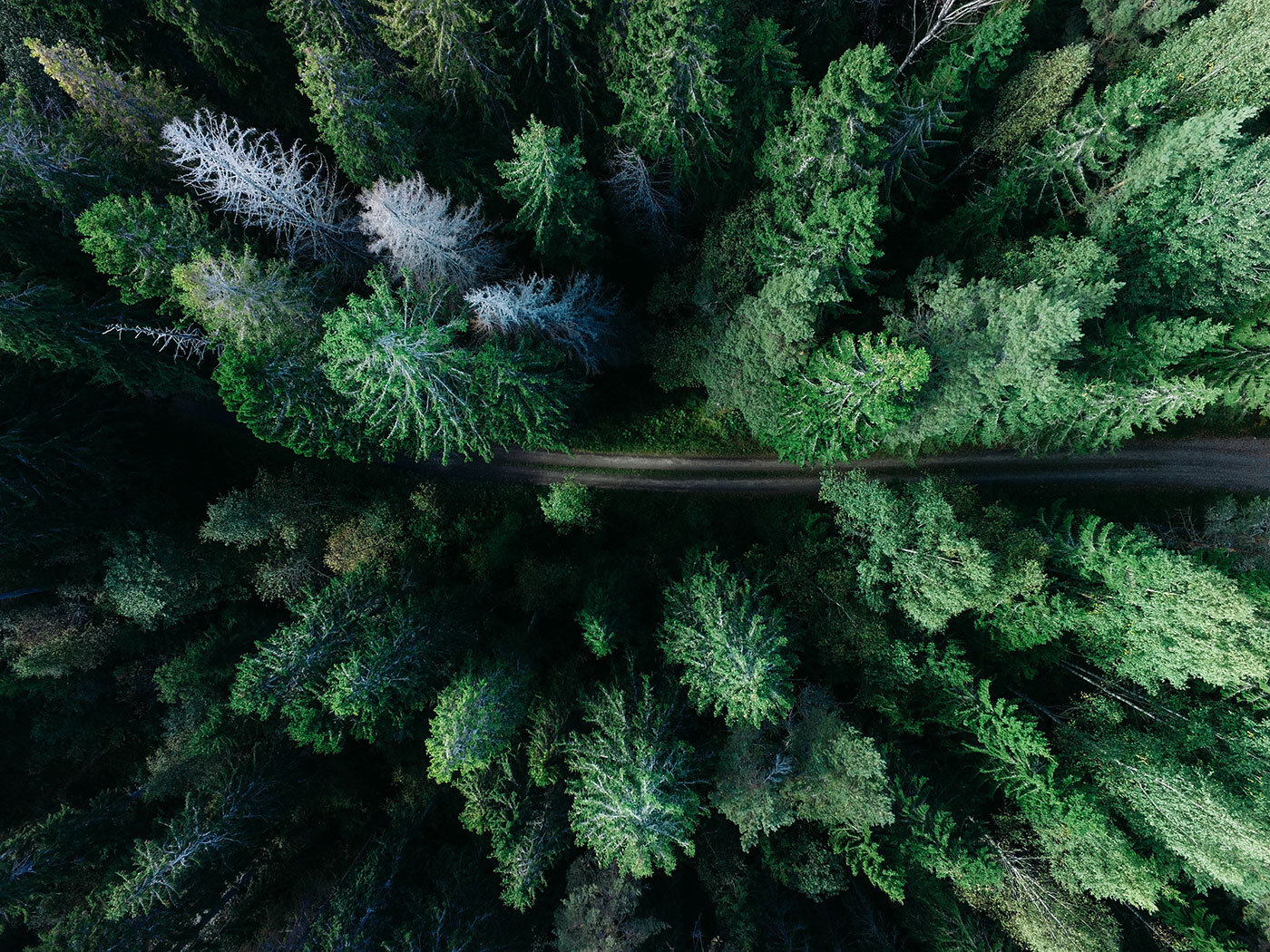
I used to think forests were just backgrounds for other photographs, something pretty to have in the distance behind a subject or a building. But spending a week in central Sweden completely changed my perspective on what wilderness photography could be. This aerial shot, taken from a drone about 300 feet above an unnamed road cutting through seemingly endless pine and spruce, captures something I’d never experienced before: the sheer scale of untouched forest that still exists in Northern Europe.
The road itself becomes almost insignificant from this height, just a thin line of human presence cutting through what looks like an ocean of green. From ground level, that road felt like the most important thing in the landscape, the lifeline connecting small towns through otherwise impenetrable woods. But from above, you realize how small our impact really is compared to the vast wilderness that surrounds it.
Sweden surprised me with how much of the country is still forest. Nearly 70% of the land is covered in trees, most of it managed but still wild enough that you can drive for hours without seeing anything but green canopy stretching to the horizon. This particular stretch was between Sundsvall and Östersund, where the road winds through what locals call “the green desert” because of how uniform and endless it appears.
What struck me most was the variety within what initially looks like monotonous forest. From this aerial perspective, you can see the subtle differences in tree species, age, and health. The lighter green patches are younger growth, probably areas that were logged and replanted decades ago. The darker, denser sections are old growth forest that might not have been touched by humans for centuries. There are even a few dead trees standing like gray ghosts among the living ones.
Flying the drone over this landscape felt like exploring an alien planet. The silence when I landed to change batteries was absolute, broken only by wind moving through pine needles and the occasional bird call. No traffic noise, no human voices, no machinery. Just the sound of a forest that extends far beyond what any single person could walk through in a lifetime.
The technical challenge of this shot was capturing the texture and depth of the forest canopy without losing the clean line of the road. Too high and everything becomes flat and abstract. Too low and you lose the sense of scale that makes this landscape so impressive. This altitude seemed to hit the sweet spot where you can appreciate both the individual trees and the vast scope of the forest itself.
I spent three days driving these forest roads, stopping frequently to launch the drone and explore different perspectives. What I discovered is that aerial photography reveals patterns in nature that are invisible from ground level. The way water carves subtle channels through the forest floor. How different tree species cluster together in ways that create natural boundaries. The geometric precision of planted forests versus the organic chaos of old growth areas.
There’s something humbling about seeing landscape on this scale. All our urban concerns about space and density and overcrowding seem ridiculous when you’re looking at hundreds of square miles of forest that probably see more elk than humans in any given year. Sweden has managed to maintain these vast wild spaces while still being a modern, connected country, which gives me hope that development and wilderness preservation don’t have to be mutually exclusive.
The road eventually led to a small town called Ånge, population about 3,000, where I stopped for coffee and to warm up the drone batteries. The locals weren’t particularly impressed when I showed them this aerial footage of their surrounding forest. To them, this is just home, as ordinary as city skylines are to urban dwellers. But sometimes it takes an outsider’s perspective to see the extraordinary in what others consider everyday landscape.